Wallanding Creek
| Rating: | |||||||||||||||||||||||||||||||
|---|---|---|---|---|---|---|---|---|---|---|---|---|---|---|---|---|---|---|---|---|---|---|---|---|---|---|---|---|---|---|---|
| | Raps:3-5, max ↨60ft
Red Tape:No permit required Shuttle:Optional 0.5mi Vehicle:4WD | ||||||||||||||||||||||||||||||
| Start: | |||||||||||||||||||||||||||||||
| Parking: | |||||||||||||||||||||||||||||||
| Condition Reports: | 22 Jun 2024
"Nice day out before flow is too low to be fun. We noticed several small siphons; in higher flow special care should be taken as the siphons were loca |
||||||||||||||||||||||||||||||
| Best season: | June-Aug
|
||||||||||||||||||||||||||||||
| Regions: | |||||||||||||||||||||||||||||||
Introduction[edit]
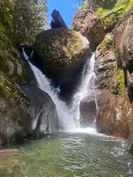
Wallanding Creek features an impressive short slot canyon that has several in-the-flow rappels, three jumps up to 20 feet and one potential 15 foot waterslide. On one rappel, you'll experience a towering chockstone with a cave, draping ferns, and mirrored waterfalls which converge in a three feet wide crack. The crux rappel is another narrow crack with overhead water. Short and convenient to combine with other short canyons in the area for a double header. Watch for dirt bikes on the road.
- Update 2023: There is one bad spot on the approach road where a small landslide is partially obstructing access. High clearance 4WD or AWD required. The last mile is quite jagged and bumpy.
- Watershed: 3mi^2. High point in the watershed is about 4200ft elevation. The drainage is south-facing.
- If Wallanding is running too high for comfort, you might check out nearby Fisher Creek.
Approach[edit]
Park your vehicle(s) at a pullout where an overgrown logging road crosses FR 73 at 46.62573, -122.37376. Hike up FR 73 for 0.5 miles and locate a good spot to drop into the forest on your right. You will be leaving the road at roughly 2,450’ elevation. Hike down following a faint use trail through open forest. A small gulch will be on your left. About halfway down, cross over the gulch. Work your way down staying about 100 - 200 feet to the north of the gulch. It is steep and has a deep loose leaf floor that makes it slippery. About 150 feet to the north of the gulch and you will find a walk-in to a wide patio with room for the whole group to suit up. It is steep it is hard to see the walk in, but it becomes apparent as you get closer.
Descent[edit]
DCR = Down Canyon Right; DCL = Down Canyon Left. Be sure to scout all jumps first. Just because it was a great jump last year...
Head downstream a short distance to a giant logjam. Climb down under the logjam DCR to find R1.
- R1 - 50’ from DCR unlinked bolts, going under a gigantic chockstone in the flow. Very pretty! There is a narrow slot at the bottom. Overhead water on rappel.
- R2 (or J1) - 20’ from DCR unlinked bolts or 15’ jump off DCR ledge. This is a technical jump. Find the hole and notice the underwater ledge on the opposite wall.
- R3 (and J2) - 35’ from DCR unlinked bolts. This is the crux of the canyon where all the water funnels through a v-shaped undercut chute that is roughly 3 feet wide. This section is particularly dangerous in high flow. The last section of the waterfall bells out and the rappeller must go directly in the flow with no secure footing. It is recommended to take packs off for this rappel. There is another jumping opportunity here for a jump of 10 feet.
- DC (or J3) - At the next drop, scramble up onto a shelf DCL (may require a partner assist) and downclimb. Or jump 12’ from the obvious ledge. There is a 20 foot jump spot DCL that is slightly technical.
- DC (or J4) - After a short boulder field, downclimb either in the low-angle crack DCR or downclimb in the middle, or jump 10’ over the waterfall into a waist-deep pool. Alternatively, rappel from a log higher up.
- S1 - Next there is a potential waterslide consisting of 15’ of horizontal travel and a 5’ drop over a waterfall into a shallow pool. Pool may be waist deep to chest deep depending on the season. Or downclimb either side.
- R4 - 60' from a tree high DCL, 2-tier. Or do a dirty walk around DCL. Play in the pool if it's sunny!
On the way to the exit here are a few more short downclimbs that can be bypassed on one side or the other.
Exit[edit]
Continue downcanyon a short distance to approximately 46.62809, -122.36902 where it’s possible to scramble out of the creek DCR. Look for the "stone stairs" DCR. Exit was flagged in June 2023. Go up the stairs and hike directly uphill following the use trail gaining about 500ft in largely open forest. The going is steep at first, but straightforward. When the terrain mellows out, bear left south to pick up an overgrown logging grade - follow the grade southwest about 0.2mi on a gentle traverse back to your vehicle(s); alternatively, continue directly up to the approach road for a clean road entry and hike down about 500 feet to the vehicles.
Red tape[edit]
None.
Beta sites[edit]
Trip reports and media[edit]
Facebook Album - First Descent on June 2, 2018
Background[edit]
The canyon was first scouted on May 12, 2018 by Sid Creutz, Gilly Elor, Haruka Lipscomb, Ryan Ernst, and Tiffanie Lin where they explored the section of creek just below the confluence of Tumble and Wallanding and up to about 1700' on Wallanding Creek.
The first descent of Wallanding Creek occurred on June 2, 2018 by Barry Specht, Ryan Ernst, Haruka Lipscomb, and Tiffanie Lin. They dropped in about 2400', became quickly excited at the polished bedrock and beautiful pools, and slowly became disillusioned when the never ending slippery rock and lack of rappels continued and began chipping away at their souls. They were about to throw in the towel and call it failed FD until the canyon turned, walls suddenly grew, and the slot appeared.


