Weeping Too Canyon
| Rating: | |||||||||||||||||||||||||||||||
|---|---|---|---|---|---|---|---|---|---|---|---|---|---|---|---|---|---|---|---|---|---|---|---|---|---|---|---|---|---|---|---|
| | Difficulty:3A III (v3a1 III) Raps:4, max ↨100ft
Red Tape:No permit required Shuttle:None Vehicle:High Clearance Rock type:Sandstone, Mudstone, Volcanic Rocks | ||||||||||||||||||||||||||||||
| Location: | |||||||||||||||||||||||||||||||
| Condition Reports: | 18 Feb 2024
"The actual time was 4.5 hours. I enjoyed exploring this new canyon. The last rap, a nice 100 footer, will take you under a chock stone and into a grot |
||||||||||||||||||||||||||||||
| Best season: | Autumn to Spring
|
||||||||||||||||||||||||||||||
| Regions: | |||||||||||||||||||||||||||||||
Introduction[edit]
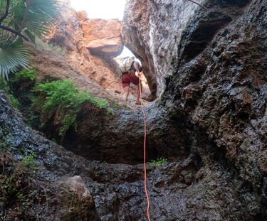
This canyon only has 4 rappels, but each rappel is satisfying with different cliff texture vertical drops. The last rappel takes you to a beautiful wet grotto once you rappel past a hanging boulder above you. The Black Canyons area allows no bolting. All rappels have boulder/rock features which make bomber anchors. The loop part of my track: south is technical descend, north is exit. If you wish to make it a full day, can head north and ascend back up (following my track) till you get to the split of lollipop and drop into Weeping Springs and hit that canyon too.
Approach[edit]
The first part of the approach is similar to the approach for Weeping Springs, which is mostly class 1 and class 2. Before hitting the 1st rappel for Weeping Springs, head southeast, then head east toward the river once it hits class 3 downclimbs. The Colorado River comes in full view when you hit the 1st rappel anchor.
Descent[edit]
Rap 1: 60' Rap 2: 50' Rap 3: 75' Rap 4: 100' (200' rope works fine for this rappel)
Exit[edit]
There are multiple ways to exit. The traditional way is to head south (turn right at the last rappel) and go back up via Big Horn Canyon. Instead of exiting Big Horn, we head north (turn left at the last rappel) and took a class 2 route between this canyon and Weeping Springs.
Red tape[edit]
Beta sites[edit]
Trip reports and media[edit]
Background[edit]
Prior to making this page, we asked multiple canyon groups and seasoned canyoneerers if this canyon has a name, as the rope anchors were already there. We did not get any answers so we just named it for the east of sharing this beautiful canyon. We had Bruce name it, who had picked this out as a potential technical canyon on Google Earth.
