Wolf Creek (Lower)
| Rating: | |||||||||||||||||||||||||||||||
|---|---|---|---|---|---|---|---|---|---|---|---|---|---|---|---|---|---|---|---|---|---|---|---|---|---|---|---|---|---|---|---|
|
| |||||||||||||||||||||||||||||||
| | Raps:6, max ↨70ft
Red Tape:No permit required Shuttle:Optional 10 min Vehicle:Passenger Rock type:alluvial deposits, harder metamorphic rocks | ||||||||||||||||||||||||||||||
| Location: | |||||||||||||||||||||||||||||||
| Condition Reports: | |||||||||||||||||||||||||||||||
| Best season: | Aug-Sep
|
||||||||||||||||||||||||||||||
| Regions: | |||||||||||||||||||||||||||||||
_Banner.jpg)
-20180911144017_pic.jpg)
-20150805025052_pic.jpg)
Introduction[edit]
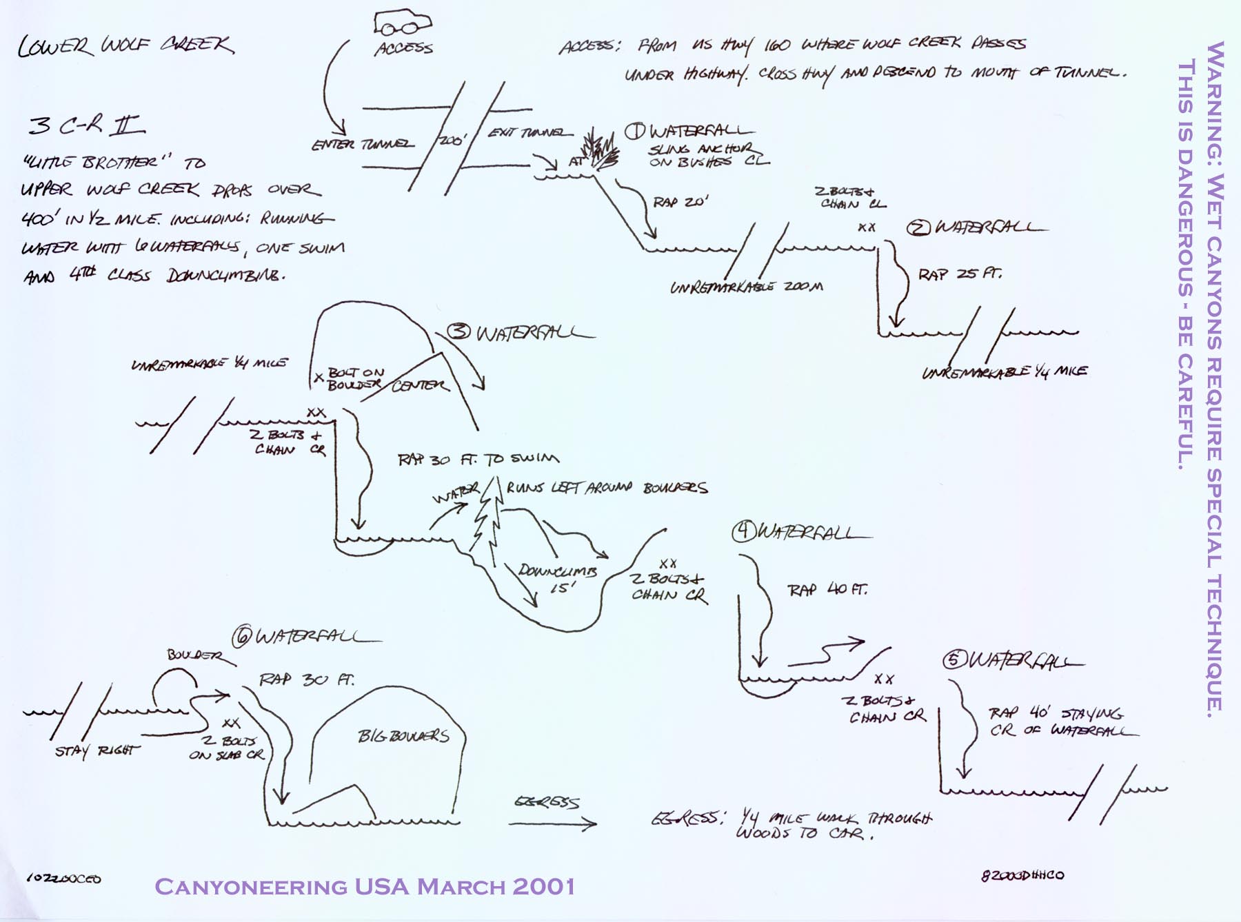
While Upper Wolf Creek is the technical adventure, Lower Wolf Creek is the more scenic of the two. However, as with its upstream brother, Lower Wolf Creek is a technical wet canyon descent and can be very dangerous. As a whole the two Wolf Creek canyons are perhaps the best technical canyon descents in the state and should not be missed by those with the proper training, equipment and experience.
Approach[edit]
Directions: Take US 160 south from Wolf Creek Pass. Park near the bridge over the creek at a hairpin turn in the highway that crosses Wolf Creek.
Logistics with Car Shuttle: You can set up a car shuttle for Lower Wolf Creek. One half mile or so past the Treasure Falls parking area, turn onto the road to Wolf Creek/West Fork Campground. Drive past the Wolf Creek campground area, crossing Wolf Creek on a bridge enroute. When you reach a Y intersection, just past the campground and roughly 1/2 mile from the highway, turn right. Take the road until it ends, less than 1/2 mile from the Y intersection, near a few marshy lakes. Park here. It is possible to camp for free near the small lakes. Bushwack 3min to Wolf Creek so that you know where to exit the river.
Logistics hiking without Car Shuttle: the USGS maps show a pack trail from the bottom parking as described to the Hwy 160 Wolf Creek tunnel. 1.75miles +780ft This trail has not been verified.
Conditions: There is no gauge on Wolf Creek, so you must eyeball the flow at the Love Tunnel and decide if you want to go on. Sections of Lower Wolf Creek offer no escape, though you can escape any time before the third waterfall by hiking steeply east up to the highway.
Entrance: Walk to the bridge. Descend to the creek on the East (upstream) side of the bridge. Hike through the tunnel under the highway (called the Love Tunnel). The first drop is at the end of the tunnel.
Descent[edit]
Walk through the large tunnel under Highway 160 from the East and rappel the first falls.
R1: 20ft off slung trees on Canyon Left
R2: 25ft from bolts CL, next to the main falls into the sometimes shallow pool below
_WolfCreekLower001.jpg)
_WolfCreekLower202.jpg)
_WolfCreekLower203.jpg)
_WolfCreekLower204.jpg)
_WolfCreekLower205.jpg)
1/4 mile of stream walking to the quick sequence of R3,R4,R5
R3: 30ft. In high water use the large Petzl glue-in to rig a hand line to a bolt station on Canyon Right for a 30ft rappel into a pool below. In low water it would be possible to rappel through the waterfall on Canyon Left off a log mid stream.
_WolfCreekLower006.jpg)
_WolfCreekLower007.jpg)
_WolfCreekLower008.jpg)
R4 (High Water): 40ft bolts CR, next to the waterfall
R4 (Low Water): 70ft rock pinch through the slippery waterfall
_WolfCreekLower009.jpg)
_WolfCreekLower010.jpg)
_WolfCreekLower011.jpg)
R5 (High Water): 40ft bolts CR. Climb over the short rock wall on Canyon Right and rappel dry to the pool below.
R5 (Low Water): 40ft bolts CR. Rappel in the waterfall in the corner on rappeller's left. Free hanging for the last ten feet.
_WolfCreekLower012.jpg)
_WolfCreekLower013.jpg)
R6: 30ft bolts CR. Rappel through the veil.
_WolfCreekLower015.jpg)
_WolfCreekLower016.jpg)
Exit[edit]
Exit: After the last waterfall the canyon opens and the banks are forested. Hike downstream for 1/4 mile or so on a fisherman trail canyon left, then canyon right until you reach vehicle left while setting the car shuttle. The trail if followed leads straight to the parking lot.
Red tape[edit]
Beta sites[edit]
Trip reports and media[edit]
Sep2018: drought year, 3 people, 2.5hrs