Yileen
Jump to navigation
Jump to search
| Rating: | |||||||||||||||||||||||||||||||
|---|---|---|---|---|---|---|---|---|---|---|---|---|---|---|---|---|---|---|---|---|---|---|---|---|---|---|---|---|---|---|---|
|
| |||||||||||||||||||||||||||||||
| | Difficulty:4B III (v4a2 II) Raps:3-6, max ↨164ft
Red Tape:No permit required Shuttle:Optional 30 min Vehicle:Passenger Rock type:Sandstone | ||||||||||||||||||||||||||||||
| Start: | |||||||||||||||||||||||||||||||
| Parking: | |||||||||||||||||||||||||||||||
| Shuttle: | |||||||||||||||||||||||||||||||
| Condition Reports: | 7 Mar 2026
"Fine. Used 6a bolted dry line for the big pitch. Great option for highly dependent parties i.e. guided parties |
||||||||||||||||||||||||||||||
| Best season: | Oct-Apr
|
||||||||||||||||||||||||||||||
| Regions: | |||||||||||||||||||||||||||||||

Introduction
Yileen Canyon is a short section of Yileen Gully, as it is marked on maps, just south of the Bells Line of Road at the Mount Wilson turn-off. It ends with a spectacular 50m abseil down a waterfall into the Grose Valley. It is a pleasant easy day, or a half-day for a faster group. A car shuffle reduces (but not eliminates) the exit walk.
Approach
Yileen is easiest with a car shuffle.
- Leave one at the bottom car park at Pierces Pass Picnic Area and drive a second car to the start at the road crest just to the south of the turn-off to Mount Wilson on Bells Line of Road.
- On the west side of the road on the crest, find the well-worn path at the northern end of the road summit rise.
- Follow the path as per the GPX. The path proceeds southwards on a pleasant ridge with good views, before descending sharply left (eastward) off the ridge into the stream.
- Rock-hop etc downstream until reaching a prominent overhang river left. Don wetsuits and harnesses here.
Descent
| Problem No. | Type | Metres | Location | Note |
|---|---|---|---|---|
| 1a | Downclimb | 2m | River centre | Or abseil 1b |
| 1b | Abseil | 5m | River left | Accessed by scrambling up on river left along a shelf |
| 2 | Slide or Down climb | 2m | River centre | If sliding be aware of small coccyx bruising ledge just under the water |
| Creek walking | ||||
| 3 | Abseil | 5m | River left | Bolts |
| 4 | Jump/down climb | 2m | River centre | Straight after pool at bottom of P4. Requires a small careful jump / drop from sitting position. Pool is shallow and can have rocks. |
| 5 | Abseil | 10m | River right | Bolts. Use access bolt for safety. Abseil down the slot. Please protect the riverine environment and do not use the trees as anchors, as they will eventually be killed by the trampling. |
| 6a | Abseil | 55m | River Right | Bolts. For safety rig an access line using the access line bolts. The preferred line. Can be broken up into a 45m + 10m (P7) Notorious for getting rope stuck on pulldown and for short ropes if doing as one long pitch |
| 6b | Abseil | 55m | River centre | Rope anchor over boulder. Wet line. Notorious for getting rope stuck on pulldown and for short ropes |
| 7 | Abseil (optional) | 10m | River right | Bolted anchor on top of large boulder/ledge with small tree on it. Drop is only done when breaking up the 50m pitch due to insufficient ropelength. |
| Most groups finish here. Exit river left. | ||||
| 8 | Abseil (optional) | 25m | River centre | Sling on tree. This drop is rarely done. |
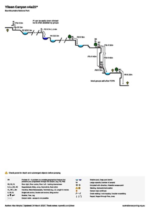
Exit
From the bottom of the big 50m abseil (P6), follow the worn path river left/east below the cliff line. Continue to traverse under the cliffs. Cross the stream and ascend up to the Hungerfords Track. Once on the track, turn left/north and follow the constructed path to the carpark.
Red tape
Beta sites
https://ozultimate.com/canyoning/track_notes/yileen.htm