Cascade Creek (Upper) (Durango)
| Rating: | |||||||||||||||||||||||||||||||
|---|---|---|---|---|---|---|---|---|---|---|---|---|---|---|---|---|---|---|---|---|---|---|---|---|---|---|---|---|---|---|---|
| | Raps:8, max ↨150ft
Red Tape:No permit required Shuttle:Optional 20min Vehicle:4WD - High Clearance Rock type:Cutler Sandstone, Limestone | ||||||||||||||||||||||||||||||
| Location: | |||||||||||||||||||||||||||||||
| Condition Reports: | 4 Jul 2025
"An absolutely amazing canyon! The calcium corridor is a uniquely beautiful feature. Nice rappels with options for rigging in high water. Due to high w |
||||||||||||||||||||||||||||||
| Best season: | July-Oct
|
||||||||||||||||||||||||||||||
| Regions: | |||||||||||||||||||||||||||||||
Introduction[edit]
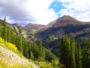
This Cascade Creek hike by Durango has lots of great press to view 8 impressive waterfalls. It's even better to descend the canyon top down. This is a great day in a spectacular setting.
Approach[edit]
From the Durango Mountain Resort, drive FS Road 578 (=Hermosa Park Rd) out of the parking lots to the north and continue as it switchbacks to the west.
At the intersection with Elbert Creek Rd, turn north (right) continuing on FS578.
Shortly, Hermosa Park Rd turns west, remain straight on FS38.
Turn right on FS579 (=Cascade Divide Road, =FS37). Follow this either to the end or drop a car at the top of the Greysill Trail for your return.
HC 4WD will have no problems. HC 2WD can likely get through - nothing is too rough. A Subaru AWD made it with care. To get an earlier start, consider camping along this road the night before.
Descent[edit]
From the upper parking lot, hike the connector trail to the Colorado Trail and continue north 2.5 easy miles with great views to the bridge over Cascade Creek. Just past the bridge is a social trail to get below a 15' waterfall to a nice suit up area on rocks above R1.
R1: 80' we used a tree on CR avoiding the flow. Beware of loose and sharp rocks on rappel. Reassess if you wanted to descend through the watercourse depending on water level.
The following gorge can all be downclimbed. Rocks are slippery until a tributary with water full of calcium carbonate from a limestone layer joins the creek. This will turn the creek from the usual mountain stream dark and clear to an impressive blue tint with whitewashed rocks and logs.
R2: 150' Pitch 1 from Tree CL. Rappel to a nice bench in the middle of the creek. 150 Foot Fall was named by hikers, however your rope lengths will be longer on this multi-pitch rappel.
R3: 70' Pitch 2 from rock pinch CR
R4: 75' Tree CR
R5: 70' Tree CR Ice Cream Scoop Fall was named by hikers. This rappel is a great cut through red sandstone and is bypassable on CR
R6: 50' rope length Tree CL Two-Tier Fall Named by hikers. Downclimb a short cascade by a picturesque pool, note the small potholes in the incoming tributary on canyon left, rappel the next 20' drop
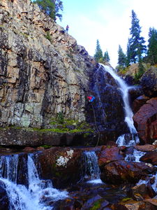
R7: 110' Tree CL Behind The Fall was named by hikers. This rappel drops over a conglomerate lip in a red sandstone amphitheater. Pad the lip to avoid rope cuts. Photos are online of people in early season ducking behind the waterfall half way up around snow from rappeller's left.
After R7, continue downstream. Note the map, exit canyon left to gain the Cascade Creek Trail for faster downstream progress. Given altitude you might be able to hike this 0.5mile without removing your wetsuit.
J1: 10'-15' Located where the Cascade Creek Trail intersects the Greysill Trail (this will be your exit). Jump back into Cascade Creek and continue 600 hundred feet downstream to R8.
R8: 85' Tree CR 50 Foot Fall was named by hikers, however this rappel requires an 85' rope. Take care to place webbing around a large solid tree away from the edge and be sure the webbing does not extend beyond the brush to keep this webbing anchor obscured from hikers.
As soon as Cascade Creek opens to a meadow on the left, exit the creek and join the Cascade Creek East trail. Remove your wetsuit for the return hike.
Exit[edit]
At Jump J1, head West up the Greysill Trail and proceed uphill 0.9 miles +800ft to your shuttle car.
After R8, gain the West Cascade Creek Trail by exiting after the "50 Foot Fall" waterfall and hiking up the short ridge on social trails on Canyon Right and overland less than a few hundred feet. Hike North, then join the Greysill trail up to your car.
Red tape[edit]
Beta sites[edit]
Trip reports and media[edit]
2017Sept17: First known top down descent. Ira Lewis, Lisa Purdy, Andrew Humphreys, Wayne Burns, Frank Phillips


