Cucamonga Canyon (Upper)
| Rating: | ||||||||
|---|---|---|---|---|---|---|---|---|
| | Difficulty:3B IV (v3a2 IV) Raps:4, max ↨80ft
Red Tape:No permit required Shuttle: Vehicle:Passenger | |||||||
| Location: | ||||||||
| Condition Reports: | 12 Aug 2021
"Used my 3mm shorts/shirt wetsuit.. came in handy through this long endless canyon.. although it is magical and great it is at the up most very demandi |
|||||||
| Best season: | ||||||||
| Regions: | ||||||||
Introduction[edit]
If you're a fan of San Gabriel Mountain canyons, and you like a long walk, then this canyon is for you. It has gorgeous rugged narrows sections, rock-hopping for miles, a couple of unavoidable swims through crystal clear water, some opportunities for jumping and sliding, and four top-notch waterfall rappels. Don't underestimate the commitment though; including the approach you're in for a pretty long day. Also, don't underestimate the water flow as it can easily be class C.
Approach[edit]
Take icehouse saddle trail, then head towards Coucamonga peak, which, if you haven't had a chance to get up there, has a pretty epic view. The drop in to the canyon is at a beautiful, obvious windy saddle between Coucamonga and the Ontario/Bighorn ridge. If you notice you're going uphill again, you've gone too far.
Descent[edit]
After descending the non-technical upper section from the Cucamonga Saddle you will reach a sharp S bend in the canyon at 34.20489, -117.61202. There is a deep saddle about 20 feet above the canyon floor RDC which connects to the other side of this S bend. Right after this is where things get fun!
R0 25 feet / downclimb 2x 10 feet: rig a rappel there or in the water course LDC / or 2 down-climbs directly against canyon wall right
S1 20 feet: low angle slide with a 2 foot drop right at the start, R1 immediately follows
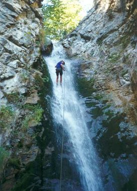
R1 65 feet: Upper Cucamonga Falls, money rappel #1, Rig off a large tree DCL directly into the water at the lip, and down 50 feet of moss covered drop into a waist deep pool.
Note: scree field DCL can be used to climb up to rock ledges and back to a chute, rappel chute to get back to the R1 top. The chute can be climbed up to bypass R1, but it's a bit sketchy
Ro 20 feet: large boulders jumbled across the canyon make for an awkward downclimb (slimy and sketchy when wet), rig off a large tree
R2 20 feet: wide vertical drop, rig from trees much further back, or angle up on dirt DCL to a tree for a 50 foot rappel down a dry slot
Ro ?? feet: at a large tree beyond a huge sloping boulder are several awkward downclimb options, better as a rappel.
Continue approx 1/2 mile down canyon with many short downclimbs
R3a 25 feet: downclimb to a pool and rig from a knot chock at head level DCR, or downclimb massively snarled deadfall DCL
R3b 25 to 50 feet: several options to rappel this jumble of massive boulders at 34.19805, -117.61533
Note: before R4 is a short wide drop into a pool which is easy to downclimb dry, but sketchy wet and slimy
R4 80 feet: Lower Cucamonga Falls, money rappel #2, This 50 foot nearly vertical drop can be rigged about 30 feet back from a large dead tree spanning the canyon about 15 feet up (easily reachable DCR) This tree works great for ghosting. The rappel itself can be done nearly dry by using a 1 slot DCR to hold your rope from angling into the waterfall itself. In high flow this make it easy to rappel with packs on into the waist deep pool.
Continue another approx 2 miles to the access road. You cannot miss the exit, because the creek goes through a steel culvert pipe.
Exit[edit]
The access road has been closed for a while due to the closure of Lower Cucamongo Canyon, so instead of having a car at the bottom of the canyon like in Brennen's day, you have to walk a couple of miles over open dirt and paved road to the neighborhood below. This moves the shuttle car drop point to somewhere around 34.165075, -117.628966, but you cannot park a vehicle here; see Red Tape below.
Red tape[edit]
A parking permit is now required to park at the bottom of Cucamonga Canyon. It is free for residents of Rancho Cucamongas, who must first register their vehicle, and $20 per day for visitors. Permits are limited, first come first serve, and allow parking along Almond Street. More information and a link to purchase a permit can be found at the Rancho Cucamongo Paid Parking Program website. Parking is free if you park sufficiently far away into the neighborhood, adding an additional 1/2 mile to the hike, just look for the absence of "Parking by Permit Only" signs.
Stay on Big Tree Cucamonga Road while exiting to avoid the closure area, which is West of the road. The closure is in effect through April 23, 2020 per Forest Order #: 05-12-53-19-02. View the map and Forest Order. After the current Order expires, check the San Bernardino National Forest list of closures for updates.
Beta sites[edit]
 Chris Brennen's Adventure Hikes (St Gabriels) : Upper Cucamonga Canyon
Trip reports and media[edit]
Background[edit]
First known canyoneering descent by: Garrett Reisman, Simone Francis and Chris Brennen on September 13th, 1997
