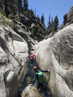
Deer Creek (California Sierras)
| Rating: | |||||||||||||||||||||||||||||||
|---|---|---|---|---|---|---|---|---|---|---|---|---|---|---|---|---|---|---|---|---|---|---|---|---|---|---|---|---|---|---|---|
| | Raps:3-12, max ↨70ft
Red Tape:No permit required Shuttle:Required 15-70 minutes Vehicle:Passenger Rock type:Granite | ||||||||||||||||||||||||||||||
| Location: | |||||||||||||||||||||||||||||||
| Condition Reports: | 14 Aug 2021
"Technical obstacles in the canyon were fun and straightforward, but lengthy creek-walking sections and the exit hike made for a long and grueling day. |
||||||||||||||||||||||||||||||
| Best season: | July-Sept
|
||||||||||||||||||||||||||||||
| Regions: | |||||||||||||||||||||||||||||||
Introduction[edit]
Deer Creek is a very pleasant nearly full day canyon in the Dinkey Creek area, about halfway between Shaver Lake and the Jump Trip canyons. With a variety of options for rappelling, jumping and sliding in or out of the water and generally short rappels, it is a good choice for those looking for something different in the area, or slightly less challenging than some of the other nearby canyons. The in-canyon travel distance is relatively long, however, so the length of commitment shouldn't be underestimated.
Approach[edit]
Spot a car at one of 3 locations:
- Option 1: 36.987896, -119.101806 on 11S95 for a ~15 minute 1 way shuttle, 1400', 2 mile exit hike with some bushwacking
- Option 2: 36.999065, -119.116302 on 11S32 for a ~70 minute 1 way shuttle, 250', 0.1 mile exit hike (note that this also adds 0.8 miles of creek walking. As of August 2021 the gate to 11S32 from Ross Crossing Rd is closed and locked. Successful completion of this approach has not been documented.)
Return to the bridge where Ross Crossing Road crosses Deer Creek, scramble down to creek upstream of bridge and proceed downstreem
Descent[edit]
The canyon consists of 3 main sections:
The initial non-technical creek
Walk/run/bushwack through the first mile or so of the non-technical portion. You may wish to slide/jump as well if the temps are acceptable. There are large portions of flat granite slab, with occasional bushwacking around pools. You will come to a pool with an option for a 15' slide, or a downclimb DCR, at which point you may chose to suit up. Continue another 0.5 miles to the first rappel.
The technical section
The technical section contains 8-12 rappels, all under 70' in length. Obstacles are generally grouped, with stream walking in between various groups of obstacles. Bolts and pins exist where needed, though many of the noted rappels can be downclimbed or jumped, depending on comfort/skill level.
All rappel lengths are approximate.
*R1 25' from bolts canyon left
*R2 25' from a pinch point canyon left (may also be carefully downclimbed/slid)
*R3 (65' from bolts high on a slab canyon left) bypasses a series of potholes, one of which has an underwater arch (noted by lack of visible outflow from the top). This pothole/arch can present an escape hazard even at low flows, but the arch has been swam through to escape this pothole.
*R4 30' from bolts canyon left
*R5 40' from bolts canyon right
*R6 60' from bolts atop a large boulder canyon center
*R7 60' from two pitons in a crack below or downclimb to jump ~25' into a large, deep, but shady pool.
*R8 40' from a dead tree DCR to a short but deep pool (filled with log debris as of summer 2020).
*R9 65' from a 2 bolt (+ 1 pin?) anchor down the mossy watercourse
*R10 35' from piton in hard-to-see crack DCR, or downclimb and jump ~20'
*R11 70' from an oak tree canyon left to a large, deep pool. For extra excitement, try rappelling ~55' in the flow and off rope via a slide (this was not attempted by the author but looked fun)! Send someone down on rope first, debris in the pool may be hidden from the top. Optional bypass may exist DCR
*R12 Downclimb DCL (or slipperier, DCR) or rappel DCR from a single pin with a quicklink, 15'.
The exit portion of the creek
After the final rappel, the creek continues to the exit, with a more dense, wooded feel. After Bull Creek enters on your left, there are no more mandatory swims, though you may wish to keep your wetsuit on until leaving the stream.
Exit[edit]
Option 1:
If your vehicle is at 36.987896, -119.101806 on 11S95, continue past Bull Creek to another creek 0.37 miles later. Follow a faint use trail southwest uphill to an overgrown road/trail. Follow the trail until joins 11S32, turn left uphill and follow the road up the ridge, bearing right at the fork. When the road ends, continue another 1/2 mile and 600' on the ridge following bear/cow trails until you meet the road
Option 2:
If your vehicle is at 36.999065, -119.116302 on 11S32, continue past Bull Creek 1.1 miles and scramble up a ridge 250' to your car. This option has not been documented, so verify that the ridge is climbable before leaving the shuttle there. If the ridge cannot be climbed, follow the exit above the road, and bear right instead of left onto 11S32 down to your car.
Red tape[edit]
Beta sites[edit]
Trip reports and media[edit]
Background[edit]
First known descent by Jef Levin and co. in September 2016. Documented by Morgan Diefenbach, John Bowling and Andrew Wimmer August 2, 2020, with evidence of many descents more recent than 2016 found.
