Englestead Hollow
| Rating: | |||||||||||||||||||||||||||||||
|---|---|---|---|---|---|---|---|---|---|---|---|---|---|---|---|---|---|---|---|---|---|---|---|---|---|---|---|---|---|---|---|
| | Difficulty:3B IV (v4a1 V) Raps:11-15, max ↨250ft
Red Tape:Permit required Shuttle: Vehicle:Passenger Rock type:Sandstone | ||||||||||||||||||||||||||||||
| Location: | |||||||||||||||||||||||||||||||
| Condition Reports: | 11 May 2025
"Fun big drop and a fairly pretty slot! We rigged the tree far down canyon left and avoided the ice slab and pool.. Very little water in canyon. Al |
||||||||||||||||||||||||||||||
| Best season: | Late Spring; Summer; Fall
|
||||||||||||||||||||||||||||||
| Regions: | |||||||||||||||||||||||||||||||
Introduction[edit]
A sudden, impressive, series of drops to the canyon bottom followed by a succession of rappels and winding narrows. Eventually joining with Orderville.
Approach[edit]
Englestead has a few options to choose from when descending
- The ideal and perhaps easiest route, is shown on the map; shuttle required with one vehicle parked at the Visitor Center, another parked in the back country, and doing the full route which is following Englestead until it meets Orderville which meets the Virgin River that you follow downstream until you reach the last stop of the Zion Shuttle. This route requires a permit.
- Can use a commercial shuttle from the Visitor Centre which will allow a no/one-vehicle Englestead-Orderville-Narrows trip; search "Zion Private Shuttles". E.g. Red Rock Shuttles departs from the VC at 6:00 AM and drops off close to the Englestead trailhead.
- For a no-shuttle loop option exiting up Orderville, see RoadTripRyan's beta for approach, and additional exit information using Wild Wind Hollow below.
Descent[edit]
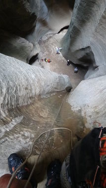
The canyon drops abruptly. The first anchor is a tree LDC near a small corner about 50+ feet from the head of the canyon; follow the trail slightly away from the cliff edge, then back to the edge. You can walk RDC a little and get a pretty good view of the first rappel including the mid-wall rappel station 90' below, under a block of rock. There often is webbing on a tree close to the canyon head, but the pull on this station can be a problem and there is no intermediate station so a 300 foot rope is required. Another option is to rappel down the center of the watercourse which is 250' from one of a couple of trees 15-20' back from the edge. This rappel is somewhat less vertical than the one above and the pull is easy.
Rappels[edit]
- R1: 290 feet - Anchored from pine tree LDC. OR 250 feet - Anchored from a tree ~20' back from the edge canyon center.
- R2: 35 feet - Anchored from boulder.
- R3: 30 feet - Anchored from boulder.
- R4: 100 feet total - Anchored from log 8 feet from bottom of rap 3. (20 feet to pot hole then 80 feet down water flute)
- R5: 20 feet - Anchored from a log just above the floor from the top of the rap.
- R6: 10 feet - Anchored from a log at the top of a log jam. This rap is a little awkward.
- R7: 15 feet - Anchored from wedged boulder in rock fall.
- R8: 15 feet - Anchored from rock 10 feet overhead RDC.
- R9: 10 feet - Anchored from half buried log.
- R10: 20 feet - Anchored from buried choke stones.
Rappel 1[edit]
Standard Rappel 1: 300' from a tree LDC to the canyon bottom OR 250' from a tree ~20' back from the edge canyon center.
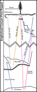
Alternate Rappel 1: 90'/28m (a 60m rope works) to a small ledge (1 square foot) anchor station with 2 bolts to the rappeller's right, which has room for 2 people to clip in (very exposed, see video below). There is a larger ledge right of the bolts with a single angle piton pounded halfway into a drill hole (not a single point safety!), which allows for 2 or 3 more people to stand. From here it's 150' to a large platform suitable for 10+ people. There is a bolted rappel station from this platform 50' to the bottom. See diagram below. This option can be done by two people with 2 x 200'/60m ropes; or a larger party with 3 x 200'/60m ropes (of which one can be 2 x ≥30m knotted).
Also, there is another rusty bolted station in the water streaks about 100 feet below the 90' station. This station had webbing and rap ring that had heavy mineral deposits on it. The webbing and ring were removed 20JULY2019. It is assumed that this station was installed to allow 120 foot (40 meter) ropes to be used to do the whole canyon. This station is not on the diagram below.
After the 300ft rappel there are an additional 10-15 rappels depending on canyon conditions ranging from 10ft to 100ft. Most are off chockstones or logs. The last rap is off a deadman/cairn, although it can be climbed around canyon left.
Exit[edit]
Englestead Hollow is fairly short and soon comes to Orderville. Depending on your comfort level of down climbing, you can remove your harness here, or just keep it on. You will follow Orderville down canyon until it meets the narrows and then exit via the Temple of Sinawava. Having your wetsuit on for the narrows is fun, as you can avoid the bottlenecks caused by hikers and just stick to the watercourse. You can often just float down, making progress much quicker.
No-shuttle loop exit up Orderville: if you prefer to exit up Orderville, you can take a right at Wild Wind Hollow (37.3244, -112.8703) and make your way up the well-worn trail back to your car. This works as a loop if you parked your car on N Fork County Rd here: 37.3068, -112.8608. Keep in my mind that exiting up Orderville from the end of Englestead requires one somewhat challenging (but doable) up-climb. More information can be found here: http://web.archive.org/web/20240229153613/http://canyoncollective.com/threads/birch-hollow-zion-exit-information.24889/
Red tape[edit]
Permits are required to enter and descend this canyon as it is located within the Zion National Park boundaries
Beta sites[edit]
 BluuGnome.com : Englestead Canyon
 Chris Brennen's Adventure Hikes (Southwest) : Englestead Hollow
 RoadTripRyan.com : Englestead Canyon
 CanyoneeringUSA.com : Englestead
 Climb-Utah.com : Englestead Hollow
 CanyonChronicles.com : Englestead Hollow
 Zion Canyoneering Book by Tom Jones : Englestead Hollow
 ToddsHikingGuide.com : Englestead Hollow
 CanyonCollective.com : Englestead Hollow
 Super Amazing Map : Englestead Hollow
 ZionCanyoneering.com : Englestead Hollow
Trip reports and media[edit]
- https://www.stavislost.com/hikes/trail/englestead-hollow
- https://www.facebook.com/pat.winstanley.7/media_set?set=a.544044052320963.1073741845.100001461198708&type=3
- Bogley trip report http://www.bogley.com/forum/showthread.php?75887-Englestead-Hollow-Zion-NP
 Candition.com : Englestead Hollow
Alternate Routes[edit]
Alternate approaches are added here for reference and only ones that I have personally done myself, and can confidently tell you that the full route is the best, easiest, and funnest route. estunum (talk) 18:38, 3 September 2017 (EDT)
- As a loop: Please refer to map here. This route will still require a permit as you will meet Orderville and down the narrows as the standard route. When you reach the Temple of Sinawava shuttle stop, take the shuttle down and get off at the Weeping Rock stop. From here, follow the signs to the East Mesa Trail and head steeply towards Observation Point. You've invested a large amount of energy, so you might as well take the detour to Observation Point and enjoy a quick break. Should be a couple hours to Observation Point from the shuttle stop. From there, the hike eases off and it's another ~3.75 miles to your vehicle. Follow the East Mesa Trail until you reach its upper trail head, where you will see parked vehicles. Hike past this and make your first left onto the ATV road used to approach the beginning of the hike and back to your vehicle. Your entire group doesn't have to do this, as we opted. The two fastest hikers make the climb back to the vehicle, while the rest of the group took the shuttle back to the Visitor Center and waited for their return. This route is an option if you insist on doing the canyon and don't have a second vehicle. estunum (talk) 18:38, 3 September 2017 (EDT)
- Hike up Orderville: Please refer to map here. On this approach you hike UP Orderville instead of down. It was unclear years ago if you needed a permit for this route, but the permit system clearly has this as an option now, so this route also requires a permit. Referring to the map, you set you exit vehicle by following North Fork County Road north until you come to a fork around 37.3368, -112.8303, you take the left and make an immediate sharp left onto a narrow dirt road. It is recommended to have high clearance on this road. While NF County Road is well maintained, this one isn't as much. It may be required at times to have a 4x4 vehicle. You take this road ~2.5 miles until you reach a round open area, there should be sign here. Drop off your vehicle and drive back the same way back and follow the map to the start of Englestead. The canyon is done as usual, but when you reach Orderville you make a right and hike upstream. There will be at least 1 substantial obstacle, a larger boulder blocking the width of the canyon that you have to negotiate. You will hike past Birch Hollow and may run into herds of cattle. You hike up Orderville almost 8 miles before you reach your vehicle. estunum (talk) 18:38, 3 September 2017 (EDT)

