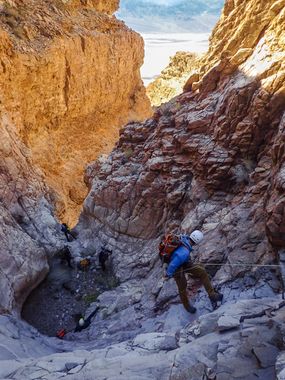
Erebus Canyon
| Rating: | |||||||||||||||||||||||||||||||
|---|---|---|---|---|---|---|---|---|---|---|---|---|---|---|---|---|---|---|---|---|---|---|---|---|---|---|---|---|---|---|---|
| | Difficulty:3A IV (v3a1 IV) Raps:20, max ↨150ft
Red Tape:No permit required Shuttle:Required 38.1 mi Vehicle:Passenger | ||||||||||||||||||||||||||||||
| Start: | |||||||||||||||||||||||||||||||
| Parking: | |||||||||||||||||||||||||||||||
| Shuttle: | |||||||||||||||||||||||||||||||
| Condition Reports: | 16 Feb 2025
"Absolutely stunning route! Beautiful outlandish coloring and striping embedded in smoothed over limestone. I was truly blown away, never seen such an |
||||||||||||||||||||||||||||||
| Best season: | Nov-Mar
|
||||||||||||||||||||||||||||||
| Regions: | |||||||||||||||||||||||||||||||
Introduction[edit]
Approach[edit]
From the junction of highways 178 (Badwater Road) and 190, drive about 10.7 miles east on highway 190 to the turnoff for Dante's View. Follow the signs to Dante's View, which is another 13.1 miles.
From the Dantes View parking lot, start hiking north on the unsigned but obvious trail up the ridge. After 3.0 miles, fork left off the trail, continuing north on the ridge for a couple-hundred feet to the top of a small hump. This is the top of "Erebus Ridge," a west-facing ridge that is the approach for canyons Typhon4, Erebus, Purgatory, and Purgamal, and an alternate approach for Abysmal.
Turn left and head west-northwest down Erebus Ridge for about .6 miles, descending about 900 feet. This spot is not very obvious, except the terrain to the right (north) finally looks reasonable, and there are now (after 14 years of canyoneering traffic) even signs of human foot traffic.
Head down the slope to the north, into the drainage. This is an upper drainage of Typhon4.
Head downcanyon in Typhon4 for a couple-hundred feet and then exit up the slope to the right (north).
At the top of the ridge, turn right (northeast) and contour over to the next drainage. This drainage is the top of Erebus Canyon.
Descent[edit]
Rap 1: 40ft.
Rap 2: 60ft.
Rap 3: 50ft.
Rap 4: 85ft, 2-stage.
Rap 5: 60ft.
Rap 6: 60ft.
Rap 7: 50ft.
Rap 8: 30ft.
Rap 9: 90ft.
Rap 10: 140ft.
Rap 11: 70ft.
Rap 12: 150ft.
Rap 13: 110ft, 2-stage.
Rap 14: 25ft.
Rap 15: 110ft.
Rap 16: 50ft. Or 150ft, 2-stage, including rap 17, but hard rope pull this way.
Rap 17: 40ft. Or done as second stage of rap 16.
Rap 18: 145ft, 2-stage.
Rap 19: 75ft.
Rap 20: 20ft. Or downclimb.
Rappel length is rope length, not drop height. All rappel lengths are approximate. Some are only estimated, not actually measured. Numbers provided as a rough guide only. Be aware of your surroundings and do not blindly follow any canyoneering info. Max rap length of 150 feet is an approximation.
Exit[edit]
About .6 miles of easy downhill alluvial-fan walking to the road.
Red tape[edit]
Beta sites[edit]
 BluuGnome.com : Erebus Canyon
 Super Amazing Map : Erebus Canyon
 Stav is Lost : Erebus Canyon - January 31, 2025
Trip reports and media[edit]
Background[edit]
Discovered and named by Rick Kent. First descent, 15 March 2008: Rick Kent and Mike Cressman. The trip through Erebus in 2008 was the first exploration of several worthy canyons that start at Dantes View and finish north of Badwater: Typhon1 through Typhon4, Erebus, Purgatory, and Purgamal.
