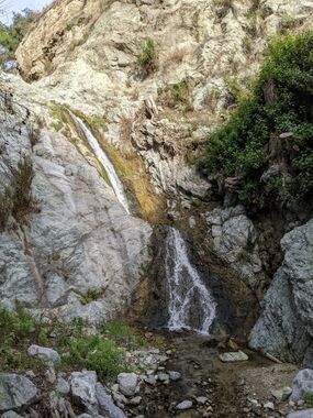
Monrovia Canyon
Jump to navigation
Jump to search
| Rating: | |||||||||||||||||||||||||||||||
|---|---|---|---|---|---|---|---|---|---|---|---|---|---|---|---|---|---|---|---|---|---|---|---|---|---|---|---|---|---|---|---|
| | Difficulty:3A IV (v3a1 IV) Raps:11, max ↨80ft
Red Tape:Permit required Shuttle: Vehicle:Passenger | ||||||||||||||||||||||||||||||
| Location: | |||||||||||||||||||||||||||||||
| Condition Reports: | 6 Jan 2024
"Parked at the intersection of Ridgeside and Canyon. Hiked up the Clamshell Truck Trail and then the firebreak to Clamshell Peak since I didnt have a |
||||||||||||||||||||||||||||||
| Best season: | Spring;Summer;Fall;Winter
|
||||||||||||||||||||||||||||||
| Regions: | |||||||||||||||||||||||||||||||
GPS data automatically extracted from brennen.caltech.edu, please visit their site for more detailed information.
Introduction[edit]
Approach[edit]
Descent[edit]
Exit[edit]
Red tape[edit]
Entry to this area may be restricted; check for information regarding permits before attempting this trip
Monrovia Canyon Park has been closed by the City of Monrovia due to the Bobcat Fire and would likely affect the legal exit from this canyon. The Bill Cull and Four Palms Trails provide a way to bypass closed gates.
Beta sites[edit]
 Chris Brennen's Adventure Hikes (St Gabriels) : Monrovia Canyon
 Super Amazing Map : Monrovia Canyon
 SummitPost.org : Monrovia Canyon
Trip reports and media[edit]
Background[edit]
First known canyoneering descent by Troy Sette, Clancy Rowley and Chris Brennen on Jul.24, 1999.
