Morning Star Canyon
| Rating: | ||||||||||||||||
|---|---|---|---|---|---|---|---|---|---|---|---|---|---|---|---|---|
| | Difficulty:3B III (v3a2 III) Raps:3, max ↨197ft
Red Tape:No permit required Shuttle:None Vehicle:High Clearance Rock type:sandstone | |||||||||||||||
| Location: | ||||||||||||||||
| Condition Reports: | 6 Oct 2023
"Not worth doing imo. Its mostly boulder hopping in non technical terrain and not scenic at all. Only two required raps, neither of which are good qua |
|||||||||||||||
| Best season: | ||||||||||||||||
| Regions: | ||||||||||||||||
Introduction[edit]
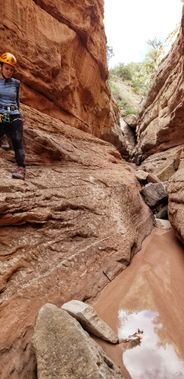
Morningstar canyon is a technical canyon in the Black Ridge Wilderness. It features an impressive section of sandstone narrows that must be rappelled into and out of, and a huge free hanging last rappel into a beautiful and secluded section of Devil's Canyon.
Approach[edit]
Morningstar canyon is approached from either Lower or Upper Black Ridge Road depending on time of year. The Upper Road is open from April 15 - August 15, with the Lower Road being open from August 15 - February 15. Both roads are closed to motorized travel from February 15 - April 15
If approaching from the upper road, reset your odometer at the Black Ridge Road parking area just off of Rimrock Drive outside the boundaries of Colorado National Monument.
Drive Black Ridge access road for approximately 3.4 miles from the start, being sure to stay on the upper road. Look at the map closely (Google Maps works well) and park in the sage flats where the lower and upper Black Ridge roads are closest together. Follow the map. There aren't very many distinguishing features on the Mesas above the Black Ridge canyons, so good navigation and map reading skills are essential.
Descent[edit]
If you parked on the upper Black Ridge road, find a way down the ridge to the north east of where you parked, cross the lower Black Ridge road, and enter the drainage. Continue north east in the wash until you come to the narrows and the first mandatory rappel.
Rappel 1:
15 feet off a well established shrub in the center of the wash.
There isn't much in the way of anchors for this short rappel aside from a couple of rocks and a small bush in the wash. Both have been field tested successfully.
The Narrows:
Arguably the best section of Morningstar canyon these sandstone narrows can hold a considerable amount of water. The water can be stemmed across, and avoided by traversing the narrow rock benches above the pools. In short order you'll come to the next rappel.
Rappel 2: 104 feet off of a sturdy chockstone.
During Morningstar's first descent in November of 2019, approximately 25 feet of new webbing and an 8mm quicklink was left behind for this rappel off a jammed chockstone in the watercourse. During a return trip in June of 2020 both the webbing and QL were found to be SEVERELY weathered despite only 8 months having passed. Examine this anchor/webbing closely. It will likely need to be replaced.
The 2nd rappel is just over 100 ft and lands you in a large room with a big pothole. There is ample room to avoid the pothole at the bottom of the rappel, but care should be taken with the rope toss. If you rappel out of the bag instead of throwing the rope, you can avoid getting the bag and rope wet.
From the bottom of the second rappel, continue down canyon a few minutes downclimbing through some beautifully sculpted sandstone in the watercourse to the final rappel.
Rappel 3: 197 feet off a tree.
You'll need every bit of a 60m rope to complete Morningstar's final rappel. The current anchor is from a medium sized tree just above the lip on canyon right. No webbing is neccessary if you intend to do the climber's exit after the last rappel as the rope can be left anchored to the tree and retrieved during the exit.
