|
|
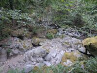
| Location:
|
Damnation Creek
|
| Reported by:
|
Coops
|
| Date:
|
24 Aug 2025
|
| Comment:
|
View from the path at the end of the forest road (48.62878, -121.34182)
|
| Waterflow:
|
Moderate-High
|
- Very Low: Water flow should not represent any danger (class B = a2).
- Low: Not as fun, but should be safe even for beginners (class B/C = a3).
- Moderate-Low: A bit low, still fun but not very challenging (class C1- = a4-).
- Moderate: Challenging but not dangerous for intermediate canyoneers (class C1 = a4).
- Moderate-High: A bit high, quite challenging but not too dangerous (class C1+ = a4+).
- High: High water, only for experienced swift water canyoneers (class C2 = a5).
- Very High: Dangerously high water, only for expert swift water canyoneers (class C3 = a6).
- Extreme: Extremely dangerous high water, may be unsafe even for experts (class C4 = a7).
|
Historical reference pictures used in Waterflow analysis
(log in to submit reference picture)