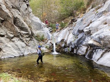
Royal Gorge (San Gabriel Mountains)
| Rating: | ||||||||
|---|---|---|---|---|---|---|---|---|
| | Difficulty:2B III (v1a2 III) Raps:0
Red Tape:No permit required Shuttle:Optional 20 min Vehicle:Passenger | |||||||
| Location: | ||||||||
| Condition Reports: | 1 Jan 2018
"Time of 6.5hrs includes the return trip to the shuttle.. You will want to bring bug spray as the black flies can be particularly bad; however they |
|||||||
| Best season: | ||||||||
| Regions: | ||||||||
Introduction[edit]
This is an archetypical San Gabriel canyon wooded with alders, canyon and scrub oaks, California bay laural, and much of the flora found in both the front county and Big Tujunga regions. The Royal Gorge flows year round making this a great adventure hike for new and experienced canyoneers alike.
Approach[edit]
From the Switzer parking lot follow the trail to Bear Canyon. At the confluence head downstream into the Royal Gorge.
Descent[edit]
The upper section of this canyon has a lot of debris, it requires bush-wacking and careful placement of your feet. By the time you reach the Royal Gorge pool, you're halfway in terms of distance but probably 3/4 in terms of time. After the pool, the descent becomes wider with less vegetation; you should cruise to the confluence of Long Canyon. The creek disappears underground for a short period helping to speed the way.
Expect to get your feet wet - wading and stomping through pools is required. Avoiding the water would add significant time to the 'descent'.
Exit[edit]
Twin Canyon Trail[edit]
The Twin Canyon Trail (marked as the 'Shuttle Exit' on the map) is in the authors' opinion the best option. From the Junction of the Royal Gorge, Long Canyon, and the Arroyo Seco, take the latter down canyon past CCC Canyon to the mouth of Dark Canyon and Oakwide Picnic area. As of January 2018, it was well-marked with yellow and orange ribbons tied to branches and easy to follow. Finding the path from the bottom could be difficult, it starts inside a small ravine with rope for a handline before trending left onto a ridge.
Long Canyon and the Gabrielino Trail[edit]
To make a loop back to where you started, avoiding a shuttle, head up Long Canyon at the junction with the Royal Gorge. There is a possibility that this area of the Gabrielino Trail is still closed from the Station Fire, but the authors have been told the trail is in good shape.
Arroyo Seco[edit]
For the longest day just continue downstream. The trail will leave the canyon bottom periodically, most notably to bypass Brown Dam. The dam can be rappelled to add a 70' drop to the trip.
Red tape[edit]
Beta sites[edit]
 Chris Brennen's Adventure Hikes (St Gabriels) : Royal Gorge
