Russell Gulch
| Rating: | |||||||||||||||||||||||||||||||
|---|---|---|---|---|---|---|---|---|---|---|---|---|---|---|---|---|---|---|---|---|---|---|---|---|---|---|---|---|---|---|---|
| | Difficulty:3B IV (v3a2 IV) Raps:3, max ↨90ft
Red Tape:Permit required Shuttle:None Vehicle:Passenger | ||||||||||||||||||||||||||||||
| Location: | |||||||||||||||||||||||||||||||
| Condition Reports: | 14 Jun 2025
"Party of 3. Russell Gulch first for all. 2nd time for Subway for one. All anchors in good condition. Removed debris in anchors and bolts and webbing f |
||||||||||||||||||||||||||||||
| Best season: | Late Spring;Summer;Fall
|
||||||||||||||||||||||||||||||
| Regions: | |||||||||||||||||||||||||||||||
Introduction[edit]
Filling in the blank sections with information based on trip on June 14, 2025.
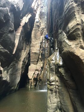
Great canyon to rappel on a clear day. Beginners should have someone more experienced in the group. There are 3 rappels. Each is about 100 feet long. Each is very likely to have water at the bottom, depending on season. The level could be high enough to make it a swimmer but that should be not a long swim: 10-15-20 feet max.
Approach[edit]
Descent[edit]
Filling in the blank sections with information based on trip on June 14, 2025.
- Rap 1: 100 feet. Anchor is straight ahead on the ledge.
There is a pool you have to wade through for less than 10 feet to get to the anchor. About 70-80 feet down, there is a pot hole. Depending on season, it may be completely full or less. On this day, it was completely full. As you get close, just push away and then land on the ledge to avoid the pothole. Depending on season, there may be deep pool at the bottom.
- Rap 2: 100 feet. Anchor LDC
Almost vertical. Depending on season, there may be deep pool at the bottom. Dirty and murky water.
- Rap 3: 100 feet. Anchored from a tree RDC.
There is another anchor setup on a ledge about 20 feet below, to make it a 2-stage rappel. Lowers the chances of rope getting stuck when pulling. Landing on flat rock. Depending on season, there may be a shallow pool at the bottom.
Exit[edit]
Filling in the blank sections with information based on trip on June 14, 2025.
If continuing on to Subway, after the third rappel hike out about a 100-120 feet. If you cliff out, you missed the path on the left for a easy hike down to the bottom of that cliff. That path is about 30 feet before the cliff, on the left. Foliage may make it challenging to notice the path.
Red tape[edit]
Entry to this area may be restricted; check for information regarding permits before attempting this trip
Beta sites[edit]
 BluuGnome.com : Russell Gulch
 Zion Canyoneering Book by Tom Jones : Russell Gulch and Subway
 CanyoneeringUSA.com :
 ZionCanyoneering.com : Russell Gulch
 RoadTripRyan.com : Russell Gulch
 Super Amazing Map : Russell Gulch
Trip reports and media[edit]
- https://www.stavislost.com/hikes/trail/russel-gulch-and-the-subway
 Candition.com : The Subway: Russell Gulch
Bogley trip report: http://www.bogley.com/forum/showthread.php?78153-Russell-Gulch-and-The-Subway-07-01-2018
