Sarita Ita
| Rating: | |||||||||||||||||||||||||||||||
|---|---|---|---|---|---|---|---|---|---|---|---|---|---|---|---|---|---|---|---|---|---|---|---|---|---|---|---|---|---|---|---|
| | Raps:9, max ↨164ft
Red Tape:No permit required Shuttle:Optional 10 mins Vehicle:Passenger | ||||||||||||||||||||||||||||||
| Start: | |||||||||||||||||||||||||||||||
| Parking: | |||||||||||||||||||||||||||||||
| Shuttle: | |||||||||||||||||||||||||||||||
| Condition Reports: | 30 Jun 2025
"The approach took a lot longer than expected. The road is very washed out and over grown, we ended up hiking up from the main road. 1hr, 1.6KM, 217M e |
||||||||||||||||||||||||||||||
| Best season: | Late Spring, Summer
|
||||||||||||||||||||||||||||||
| Regions: | |||||||||||||||||||||||||||||||
Introduction[edit]
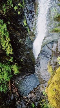
Nestled in the shadow of the Pelham Range and on the traditional territories of the Huu-ay-aht First Nations, Sarita Ita (meaning “Little Sarita”) cuts a series of scenic waterfalls on its way to joining the Sarita River. Particularly memorable is a beautiful 50m horsetailing waterfall that dives into a deep pool below. Sarita Ita is a fun day with an easy approach, easy exit, and every rappel through the flow.
Approach[edit]
Park your exit vehicle(s) at a pullout next to where the creek crosses Bamfield Road at 48.93747, -124.81263. To reach the start, continue west on Bamfield Road for 0.75km and turn right (north) onto a logging road that begins to climb steeply. Park at a pullout near where the road forks at 48.94125, -124.81777. If you don’t have a shuttle vehicle, you can easily hike the shuttle (approximately 1.4km and 100m elevation gain).
Hike up the old logging road for 1.1km and 160m elevation gain. The road becomes overgrown but travel remains fairly easy. When you reach yellow flagging (not ours) at 48.94469, -124.80728, pick the best path down to the creek through the forest.
Descent[edit]
R1 - 10m from DCC log across the pool. R1 could be a potential jump, but it is very slippery at the edge. Pool at the bottom is over 3m deep.
R2 - 30m from high DCL tree
Next is a series of drops made interesting with logjams. Multiple anchor options are available. We downclimbed nearly everything with a short rappel (R3) in the middle.
R3 - 4m off DCC log just before the creek doglegs to the right
After the creek zags sharply to the right, squeeze through a DCL rabbit hole and continue downclimbing on boulders and ledges to the bottom of the drop.
A better way to rig for future parties may be off a high DCR anchor to descend the whole series in one drop.
R4 - 12m from DCC upturned log
R5 - 4m from DCC upturned log
R6 - 12m from DCL single bolt
The next sequence is the big falls. All of the water in the creek concentrates into a horsetail falls that dives over a nearly vertical drop. Safely access the R7 anchor (it’s slippery) using a 5m traverse line from a giant tree DCR.
R7 - 50m from DCR tree near the edge. A spectacular line that takes you through the heart of the flow. You will get hammered at the bottom, and it’s great.
R8 - 20m from DCC log across the creek
After R8 there is a massive, multi-story logjam that is downclimbable DCR.
R9 - 30m off high DCR tree into a little rain room that is kind of fun
Exit[edit]
Continue downcanyon for 300m until you reach the bridge over the road. Exit the creek DCR just below the bridge and scramble up to your cars.
Red tape[edit]
Beta sites[edit]
Trip reports and media[edit]
Photos from first descent in July 2022
Background[edit]
Sarita Ita was first descended on July 3, 2022 by Kevin Steffa, Madeline Hwang, Emil Cakiryan, and Kelly Morr. Many thanks to Kevin Steffa for scouting this beautiful creek.
