Sayarim Canyon
| Rating: | |||||||||||||||||||||||||||||||
|---|---|---|---|---|---|---|---|---|---|---|---|---|---|---|---|---|---|---|---|---|---|---|---|---|---|---|---|---|---|---|---|
| | Difficulty:3A II (v3a1 II) Raps:5, max ↨50ft
Red Tape:No permit required Shuttle:None Vehicle:Passenger Rock type:Sandstone | ||||||||||||||||||||||||||||||
| Location: | |||||||||||||||||||||||||||||||
| Condition Reports: | 27 Dec 2025
"Pretty standard run through Sayarim. We actually did the South Fork version, which I highly recommend over this original Sayarim route. It has a reall |
||||||||||||||||||||||||||||||
| Best season: | Winter
|
||||||||||||||||||||||||||||||
| Regions: | |||||||||||||||||||||||||||||||
Introduction[edit]
A gentle beginner canyon with a pleasant approach through beautiful Gower Gulch. When you reach the saddle at the top of the approach, you have amazing views on both sides of the ridge: Red Cathedral and Zabriskie Point to the northeast and Badwater Basin and the Panamint Mountains to the west.
Alternate Sayarim_Canyon_Extended_(South_Fork) version adds one rappel and a couple of down climbs.
Approach[edit]
Getting there:
From Furnace Creek Inn where 190 and Badwater Rd intersect (36.4484, -116.8528), drive south for about 3.9 miles. Park on either side of the road (36.4122, -116.8456), preferably on the east side to avoid having to cross the road.
Approach:
Walk up Gower Gulch following a well-trodden hiking trail. This is part of the Golden Canyon - Gower Gulch loop which gets a lot of tourist visitation.
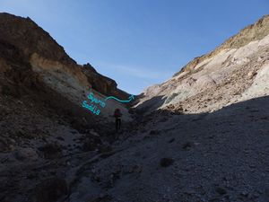
After about 1 mile (36.4170, -116.8342) you can optionally leave the crowds behind and climb up a less visited canyon which I called "Blue Canyon" (0.8 miles). This is just to add beauty to the approach. When you hit the saddle at the top of Blue Canyon, you will see two scree slopes to go down the other side, pink and blue. I think the Blue (right) side is easier but our group did both. Continue north until you reach a larger wash that leads to Gower Gulch. Turn right.
If you remain in Gower Gulch, continue for another 0.5 miles before turning right into a side canyon (36.4166,-116.8272). This is where the Blue Canyon trail lead you as well. Continue up-canyon where you will encounter a couple of gated mines and a mysterious white rock pile. (Many of the side canyons in this area have gated mines and piles of white rocks so don’t use them as an indication of the correct drainage)
Eventually you will turn right (east) into another nameless canyon which will lead you up to the saddle above Sayarim Canyon. On your way you will encounter one sketchy scree climb. Go carefully up the scree, but not too far. You may be tempted to stay on the ridge at (36.41134, -116.82380) which will take you up an additional and unnecessary 300' to Ivan's Folly (853' 36.41055, -116.82622). Although it looks like a straight shot, it does not go and adds additional hazards from large flakes of coyote sized scree. Instead, make the first left (36.41134, -116.82380) to stay in a gully that leads to the south of Ivan's Folly and is an easy stroll up a moderate slope to the saddle. Watch your step and those under you. Helmets recommended.
From the saddle it’s 1.3 miles straight down the canyon to the car, passing 5 dryfalls (6 if we count the small easy down-climb before the first rappel).
Descent[edit]
Rappels:
| Number | Tiers | Height from anchor | Anchor | Anchor Gear |
|---|---|---|---|---|
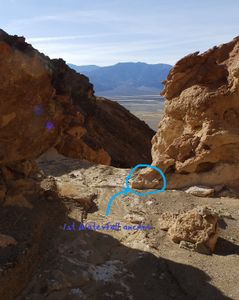
| R1 | 3 | 50ft | DCR - Loop around a leaning rock | 10-15ft Webbing or rope |
| R2 | 2 | 30ft | DCC - Loop around rock | 5-10ft Webbing or rope |
| R3 | 1 | 30ft | DCL - Cairn anchor | 5-10ft Webbing or rope |
| R4 | 1 | 20ft | Down-climb some may wish to rappel using a meat anchor | N/A |
| R5 | 1 | 40ft | DCL - Loop around 2 large boulders | 10-15ft Webbing or rope |
Rappel notes:
1. Though the anchor is at the top, we down-climbed the top tier and rappelled from there.
4. Confident canyoneers/climbers can down-climb. I had the group rappel and then down-climbed.
Exit[edit]
From the bottom of the last rappel it's a short walk back to your car across the alluvial fan.
Red tape[edit]
Beta sites[edit]
Trip reports and media[edit]
Photos from Sayarim Canyon and The Grotto : [1]
Trip 2-15-20: https://www.facebook.com/media/set/?set=a.10158131304082930&type=3
Background[edit]
First Known Descent: 1/19/2019 First Known Descent Members: Eshed Bootel, Nicole Bootel, Matan Bootel, Nadav Bootel, Gil Chotam, Ty Chotam


