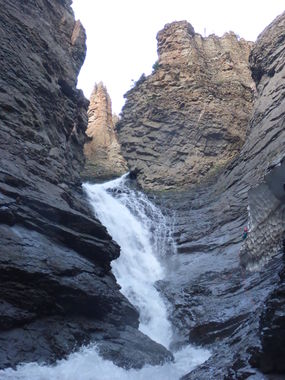
Wetterhorn Creek
| Rating: | |||||||||||||||||||||||||||||||
|---|---|---|---|---|---|---|---|---|---|---|---|---|---|---|---|---|---|---|---|---|---|---|---|---|---|---|---|---|---|---|---|
| | Raps:6, max ↨200ft
Red Tape:No permit required Shuttle:None Vehicle:4WD - High Clearance Rock type:San Juan Volcanic Tuff | ||||||||||||||||||||||||||||||
| Location: | |||||||||||||||||||||||||||||||
| Condition Reports: | 26 Jul 2014
"2014 was a higher snowpack year than previous winters. The spring melt was still in effect for Ouray canyons in late June and the water volume for Ou |
||||||||||||||||||||||||||||||
| Best season: | Aug-Oct
|
||||||||||||||||||||||||||||||
| Regions: | |||||||||||||||||||||||||||||||
Introduction[edit]
Wetterhorn Creek drains Wetterhorn Basin, which is the biggest catchment of the technical tributaries on the east side of Cow Creek and has the largest flow compared to its neighbors. Again, bring a self-sufficient and capable team as this canyon has a long approach, challenging descent, and long return in Cow Creek. The hydraulic at the bottom of R6, Wetterhorn Falls, must be avoided by rappelling with a controlled pendulum to rappeller’s right.
Approach[edit]
Hike the Cow Creek Trail from the end of CR12 to the saddle between the Roostertail Creek basin and Wetterhorn Basin. Rather than ascend the ridge to hiker's left (east), which is the approach for Middle Canyon, continue on a game trail into Wetterhorn Basin. Contour until a long grassy slope can be descended. Rappel into a final tribtuary gully with a few hundred foot rope lengths, walk downstream to intersect Wetterhorn Creek.
Descent[edit]
R1: entrance rappel of 200' or broken up into two 100' lengths
R2: 50'
R3: 45'
R4: 40'
R5: 200' around the corner on Wetterhorn Falls
R6: 100' from a second anchor in a snow cave on rappeller's right on Wetterhorn Falls.
Exit[edit]
From the bottom of the final waterfall, descend the talus to Cow Creek and streamwalk Cow Creek back to the trailhead. Estimate one mile/hour in Cow Creek.
Red tape[edit]
Beta sites[edit]
Trip reports and media[edit]
26July2014 first known descent: Ira Lewis, Lori Shindel, Tom Jones, Chris Hood
