Whungee Wheengee
| Rating: | |||||||||||||||||||||||||||||||
|---|---|---|---|---|---|---|---|---|---|---|---|---|---|---|---|---|---|---|---|---|---|---|---|---|---|---|---|---|---|---|---|
|
| |||||||||||||||||||||||||||||||
| | Difficulty:3B III (v2a2 III) Raps:3-7, max ↨51ft
Red Tape:No permit required Shuttle:None Vehicle:Passenger Rock type:Sandstone | ||||||||||||||||||||||||||||||
| Start: | |||||||||||||||||||||||||||||||
| Parking: | |||||||||||||||||||||||||||||||
| Condition Reports: | 30 Dec 2025
"Very pretty, very different.. Didnt need to do any duckunders today.. Few teams through today, one got a rope stuck on P5 and another team one |
||||||||||||||||||||||||||||||
| Best season: | Oct-Apr (avg for this region)
|
||||||||||||||||||||||||||||||
| Regions: | |||||||||||||||||||||||||||||||

Introduction
Whungee Wheengee Canyon is a spectacular canyon that flows into the Wollangambe River north of Mt Wilson. As well as impressive, narrow canyon constructions, it involves a number of duck-unders and short tunnel sections.
Approach
- From the northern carpark at Cathedral Reserve Campground, cross the road to the start of the fire trail that heads downhill in a westerly direction.
- Follow this fire trail for approximately 1.8kms. The trail climbs up a hill before reaching a clearing with a sign post for the Wollangambe Canyons. Turn right here down a foot track.
- After about 400m this track forks near a sign post and termite mount. Take the left (western) branch.
- Follow this north for another 1.2kms, initially along the ridge top before dropping downhill beside a small gully, which requires an exposed rock scramble using tree roots (and usually fixed ropes).
- Cross the river at a small sandy beach before following the track up the small gully on the other side. This takes you to the ridge on the left (west).
- Once on top of the ridge, follow it for about 800m before the track heads downhill to the right, into a dry gully.
- The gully ends at a cliff that requires an abseil from a tree of about 15.5m.
Descent
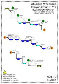
The canyon starts after about 100m of creek walking. It begins with a down climb (there are a number of possible spots to do so). Soon after this you come to the first swim, the first duck-unders, and the first chance to spot glowworms. Usually there is an air gap between the water and the rock above, but if you are concerned or water levels are dangerously high, it is possible to avoid this section on the right hand side. Some groups will abseil up to six times in this canyon, but half of these can be avoided with careful down climbing and good teamwork. There are two mandatory abseils, both of which are less than 10m. (There are currently bolts in place for both, but always ensure you have extra rope and slings in case these anchors are damaged or removed.) The canyon is extremely impressive from here to the Wollangambe River, with deep, narrow walls.
Problems
| Number | Type | Length | Anchor | Location | Notes |
|---|---|---|---|---|---|
| 1 | Abseil | 15m | Sling on tree | River right | Entry abseil. Can be bypassed - though not common. |
| 2 | Abseil | 8m | Sling on tree | River left | Can be down climbed. Most groups abseil because the down climb can be a bit tricky |
| Duck-under | First duck-under. Often an air gap exists. | ||||
| Hand-line | 3m | Sling on tree | River left | Small drop. A hand-line attached to a tree on the river left is often there to help with the descent. | |
| 3 | Abseil | 7m | Sling on tree | River left | |
| Down-climb | 2m | 4m sloping waterfall but easily down-climbed | |||
| 4 | Abseil | 5m | Sling on rock | River left | |
| Down-climb | 2m | ||||
| Creek walking | |||||
| 5 | Abseil | 9m | Bolts | River right | Approach bolt normally has fixed rope to aid access to anchor. |
| 6 | Abseil | 8m | Bolts | River left | |
| 7 | Abseil | 7m | Sling on tree | River centre | Optional. May be bypassed by down-climbing through dark boulder cave |
Topo
Exit
See the notes for Wollangambe_2. From here it is just under 1km to the exit, which is on a large right-hand bend in the river. Keep an eye out on your left for Waterfall of Moss canyon, which joins shortly before the exit. After this junction you will move through a section of boulders before reaching a small beach on river right at a point where small gullies join the river from both sides. From this beach, scramble up the steep track (passing a small arrow sign) up the gully on right (south). This track takes you up onto a major ridge which you follow south for about 1km before the track turns into a fire trail. Continue along the fire trail until you reach a clearing. Turn right and walk about 200m before heading left at the next junction. Go right at the next two track junctions, following the track downhill, through a gate, and back to your car.
Red tape
As of early 2024, the exit runs through private property. Please use the alternate exit track detailed on https://canyoning.org.au/news/wollangambe-2-exit-track-update - easy to follow but a bit rough as at 12/25.
Beta sites
Trip reports and media
- YouTube.com : Shoes On My Feet - Whungee Wheengee Canyon & First Descent Interview
Background
Named by Airdrie Long of SUBW in the mid 1980's, deliberately to be confused with the Kanangra Canyon – Wheengee Whungee Canyon. The first descent party included Tony Norman and Brad Phillips.