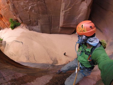
Rock Canyon
| Rating: | |||||||||||||||||||||||||||||||
|---|---|---|---|---|---|---|---|---|---|---|---|---|---|---|---|---|---|---|---|---|---|---|---|---|---|---|---|---|---|---|---|
| | Difficulty:3A III (v3a1 III) Raps:3-5, max ↨110ft
Red Tape:No permit required Shuttle:None Vehicle:4WD - High Clearance Rock type:Sandstone | ||||||||||||||||||||||||||||||
| Start: | |||||||||||||||||||||||||||||||
| Parking: | |||||||||||||||||||||||||||||||
| Condition Reports: | 14 Jul 2024
"This was a guided excursion for my wife and I through East Zion Adventures. This was our first time canyoneering. |
||||||||||||||||||||||||||||||
| Best season: | oct-apr
|
||||||||||||||||||||||||||||||
| Regions: | |||||||||||||||||||||||||||||||
Introduction[edit]
Rock Canyon descends from the southern rim of Parunuweap Canyon to the East Fork of the Virgin River. What the route lacks in sustained, sculpted narrows it makes up for in scenery and a lush, riparian lower section.
Although the trip can be shortened via sneak exit, combining Rock Canyon with Parunuweap and French Canyon makes for a more worthwhile experience. Beta provided on this page describes the latter option.
Approach[edit]
The access roads have deep sand. High clearance and 4x4 is required.
Park near the exit above French Canyon and walk the road to a pullout near the head of Rock Canyon. Follow a social trail down into the drainage and to the first rappel.
Alternatively, one could drive all the way to the end of the peninsula and exit up a developing social trail for a shorter day.
Descent[edit]
R1: 15’ bolts RDC, or downclimb.
R2: 45’ bolts LDC.
R3: 100’ bolts RDC, or moderate downclimb.
R4: 110’ bolts RDC.
R5: 40’ bolts RDC.
Exit[edit]
Turn left at the mouth of Rock Canyon and hike in and along the East Fork of the Virgin River until the confluence with French Canyon. Hike up French to an impressive, polished wall of sandstone, then pick up a trail LUC. Exiting the French drainage to the ridge above is steep, with deep sand and loose rock. Class III/IV terrain depending on which line you pick.
From the ridge, a well-used trail becomes evident and leads up to the parking area.
Red tape[edit]
Beta sites[edit]
- https://www.stavislost.com/hikes/trail/rock-canyon-and-the-barracks
- https://adamhaydock.blogspot.com/2019/10/rock-canyon-3ai-zion-national-park.html EVEN FURTHER - ROCK CANYON
Trip reports and media[edit]
 YouTube.com : Richard Pattison, Rock Canyon movie
