Stevenson Creek (Middle)
| Rating: | |||||||||||||||||||||||||||||||
|---|---|---|---|---|---|---|---|---|---|---|---|---|---|---|---|---|---|---|---|---|---|---|---|---|---|---|---|---|---|---|---|
| | Difficulty:2B II (v1a2 II) Raps:0, max ↨0ft
Red Tape:No permit required Shuttle:Optional 10 min Vehicle:High Clearance | ||||||||||||||||||||||||||||||
| Start: | |||||||||||||||||||||||||||||||
| Parking: | |||||||||||||||||||||||||||||||
| Shuttle: | |||||||||||||||||||||||||||||||
| Condition Reports: | 14 Sep 2022
"From SCE:. SCE will be making releases to Stevenson Creek again starting tomorrow, 9/14. These releases may continue to the end of September but s |
||||||||||||||||||||||||||||||
| Best season: | Jul-Oct (avg for this region)
|
||||||||||||||||||||||||||||||
| Regions: | |||||||||||||||||||||||||||||||
Introduction[edit]
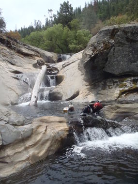
Stevenson Creek runs from Shaver Lake to the San Joaquin River. It is divided into 3 sections; Shaver_Cut_(Upper_Stevenson_Creek), middle, and Stevenson_Creek_(Lower). The middle section is a fun half-day canyon with no mandatory rappels, however, there are several short drops that could be rappelled if desired. There are lots of jumps and slides in this middle section and that would be the main draw in descending it. Most canyoneers will want to combine the Middle section with either the upper (Shaver Cut) or the Lower section for a full day.
Approach[edit]
Option #1--From Shaver Lake, CA continue on Hwy 168 to the North end of the Lake where you will turn left (north)onto Big Creek Road. There is a sign for "Big Creek" at the intersection. (Google Earth has this labeled as Huntington Lake Road) After about 1.5 miles there is a small-easily missed sign on the left (west) reading "Ely Meadow Work Camp/Musick Mountain Lookout." Turn left here. This should be Forest Road 9S65. All roads from this point on are gravel/dirt and can be rough and rutted at times. Continue on this until a 3-way fork and turn left onto Forest Road 9S03/9S22, (labeled as "Dawn Road" on Google Earth). This road will eventually dead-end at Forest Road 8S08 (labeled as "Old Railroad Grade Road" on Google Earth) Make a hard left onto this road which will lead right to (and across) Stevenson Creek at UTM 11S 293408.11 E 4114554.32 N. Park in any of the numerous available spots here, this is the beginning of the route. There is also several primitive camping options in the immediate vicinity.
Option #2: Turn left onto Big Creek road as mentioned above, travel approximately 2.5 miles towards Big Creek, and turn left onto Forest Road 8S08, there is a sign there for the city of Auberry. (If you make it to "Camp Sierra" you have gone too far) This road is also a gravel/dirt road but it is maintained/graded and in decent shape. Follow this road until it crosses Stevenson Creek.
Bonus Option #3: From Fresno take Hwy 168 North. 2 miles past the town of Prather turn north/left onto Auberry Road. Just north of the small town of Auberry turn left/north onto Jose Basin Road then a left fork/east onto Italian Bar Road to the gate described above.
Car Shuttle: Continue across Stevenson Creek on 8S08 for approx. 1.5 miles when the road makes an abrupt left (S-SW) and goes under the power lines, on your right you will see a gravel road with a gate across it, park your shuttle vehicle in the vicinity of this gate (do not block it), the best spot is just south of the gate on the west side of the road. This gate is at UTM 11S 290629.74 E 4114905.21 N {Forest Service Road 8S08C} Walking back to your vehicle parked at the drop-in is also an option as there is not much elevation gain/loss on 8S08 in this section.
Descent[edit]
Very pretty canyon with many opportunities for slides and short-ish jumps. There is the option to rappel several of the waterfalls, not mandatory though.
Exit[edit]
Follow the canyon until about 200 meters before a 600'-ish drop-off presents itself (Lower Stevenson) at UTM 11S 291110.53 E 4115633.76 N. Look for an eroded old dirt road (Forest Service Road 8S08C) on canyon left and bushwhack up to it and follow it uphill until you arrive at Forest Road 8S08 and your shuttle vehicle. There are several spur trails/roads, be sure to stay on the correct uphill path.
Red tape[edit]
Canyon is inside burn area of 2020 Creek Fire. Expect impacts to road, canyon, and surrounding area. Before going, review any relevant Sierra NF alerts and closure orders. See also Sierra NF road conditions.
